

POMINO-TROPOMI
Peking University Ozone Monitoring Instrument NO2 product for TROPOMI
Data Status:
Published
Publication State:
13 August 2020
Introduction
The POMINO-TROPOMI product is retrieved from the Tropospheric Monitoring Instrument (TROPOMI) launched on October 13th 2017. Data are available for East Asia (70-140E, 15-55N) from July 2018 to present.
TROPOMI is a UV/Visible/Near-Infrared/Short-wave infrared backscattering sensor onboard the sun-synchronous Sentinel-5 Precursor (S5P) satellite with an overpass time of 13:30 local solar time. Since 6 August 2019 (orbit 9388), the S5P operation scenario increases the spatial resolution from 7.0 km (along track) x 3.5 km (cross track) at nadir view to 5.5 km x 3.5 km for NO2 measurements (at Visible wavelengths).
The algorithm (POMINO-TROPOMI) to retrieve tropospheric NO2 measured by TROPOMI instrument is built upon our previous algorithm (POMINO) for the Ozone Monitoring Instrument (OMI). The algorithm is based on the AMFv6 package that calls the radiative transfer model LIDORT v3.6. The algorithm differences between POMINO and POMINO-TROPOMI are mainly related to instrument issues, such as available spectral coverage and spatial resolution, and details of the cloud retrieval.
Figure 1 shows the procedure of using the AMFv6 package to derive the tropospheric NO2 VCDs in POMINO-TROPOMI. It starts from taking tropospheric slant column densities (SCDs) from the official TM5-MP-DOMINO (OFFLINE) product, and further makes improvements in the calculation of tropospheric air mass factors (AMFs). Compared to the official product, POMINO-TROPOMI explicitly accounts for the daily aerosol scattering/absorbing, explicitly considers daily surface reflectance dependence on light path geometry (BRDF), and uses a priori NO2 profiles with relatively high spatial resolution, etc.
The greatest difference between TROPOMI and OMI NO2 retrievals is on the (prerequisite) retrieval of clouds. Retrieval of cloud properties is a prerequisite for NO2 retrieval. For TROPOMI, we take the cloud pressure (CP) data from the FRESCO-S cloud product (van Geffen et al., 2019), which is retrieved based on O2 A-band (around 758 nm). We re-calculate the effective cloud fraction (CF) at the NO2 fitting wavelength (437.5 nm). Since the CP is retrieved by FRESCO-S without explicit aerosol corrections and BRDF effects, potential uncertainties caused by inconsistent settings may exist. This hybrid dataset for CP and CF differs from the case of OMI, for which we re-calculate CP and CF based on the O2-O2 algorithm.
The detailed discussion of our algorithm, including a comparison with the official product algorithm, can be found in Liu et al. (2020).
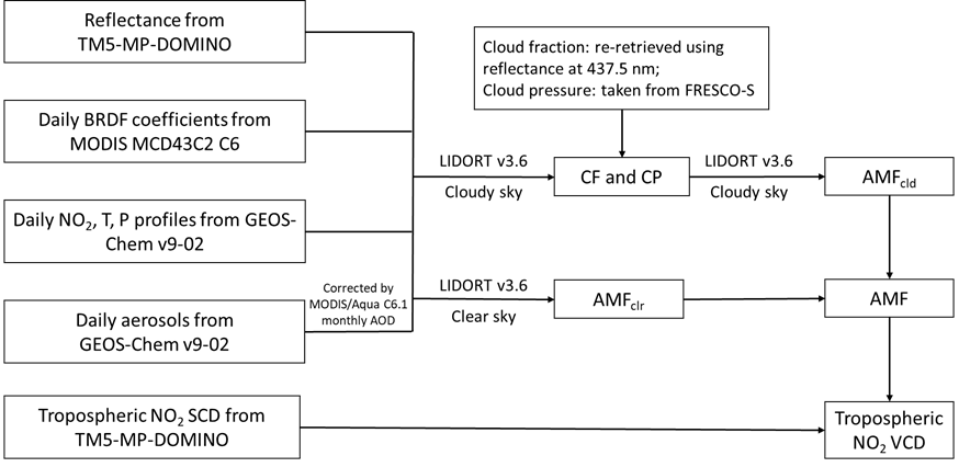
Figure 1. Flowchart of the POMINO-TROPOMI algorithm. The grey rectangles represent the parameters from the TM5-MP-DOMINO (OFFLINE) product.
POMINO-TROPOMI v1 product download
Figures
POMINO-TROPOMI v1 animation of monthly mean NO2 VCD maps (0.05 x 0.05 degree): 2019/01-2020/6
POMINO v2 (Liu et al., 2019):
On top of POMINO v1, POMINO v2 further constrains the vertical profile of aerosol extinction by monthly climatology from CALIOP, uses the SCD data from QA4ECV, and updates to MODIS (C6) merged AOD and MCD43C2 (C6) daily BRDF.
As of 2020/12/01, all Level-2 and Level-3 data are freely available.
Spatial domain: East Asia (70-140E, 15-55N).
Temporal coverage: 2018/07-present. Updates will be done from time to time depending on manpower and requests.
Level-3 data
POMINO-TROPOMI v1 Monthly or Daily Level-3 Data Download
Both daily and monthly Level-3 NO2 tropospheric VCD products are on a 0.05 x 0.05 degree grid, spatially aggregated from the Level-2 data.
Included in the Level-3 data are tropospheric NO2 AMF, tropospheric NO2 VCD, AOD at 550 nm, SSA at 550 nm, and other ancillary parameters.
See user guide for brief documentation of the variables included (NO2 VCD, AMF, AOD, SSA, etc.), as well as how to read the Level-3 data.
Level-2 data
POMINO-TROPOMI v1 Level-2 Data Download
See user guide for brief documentation of the variables included (NO2 VCD, AMF, AOD, SSA, etc.).
References
Lin, J.-T. *, R. V. Martin, K. F. Boersma, M. Sneep, P. Stammes, R. Spurr, P. Wang, M. Van Roozendael, K. Clémer, and H. Irie: Retrieving tropospheric nitrogen dioxide from the Ozone Monitoring Instrument: Effects of aerosols, surface reflectance anisotropy, and vertical profile of nitrogen dioxide, Atmos. Chem. Phys., 14, 1441-1461, doi:10.5194/acp-14-1441-2014, 2014 (PDF) (Original algorithm: proof of concept)
Lin, J.-T. *, Liu, M.-Y., Xin, J.-Y., Boersma, K. F., Spurr, R., Martin, R., and Zhang, Q.: Influence of aerosols and surface reflectance on satellite NO2 retrieval: seasonal and spatial characteristics and implications for NOx emission constraints, Atmospheric Chemistry and Physics, 15, 11217-11241, doi:10.5194/acp-15-11217-2015, 2015 (PDF) (Supplement) (Original algorithm and POMINO v1 product)
Liu, M.-Y., Lin, J.-T. * , Boersma, K. F. *, Pinardi, G., Wang, Y., Chimot, J., Wagner, T., Xie, P., Eskes, H., Van Roozendael, M., Hendrick, F., Wang, P., Wang, T., Yan, Y.-Y., Chen, L.-L., and Ni, R.-J.: Improved aerosol correction for OMI tropospheric NO2 retrieval over East Asia: constraint from CALIOP aerosol vertical profile, Atmospheric Measurement Techniques, 12, 1-21, doi:10.5194/amt-12-1-2019, 2019 (PDF) (Updated algorithm and POMINO v1.1 and v2 products)
Liu, M.-Y., Lin, J.-T. *, Kong, H., Boersma, K. F., Eskes, H., Kanaya, Y., He, Q., Tian, X., Qin, K., Xie, P., Spurr, R., Ni, R.-J., Yan, Y.-Y., Weng, H.-J., and Wang, J.-X.: A new TROPOMI product for tropospheric NO2 columns over East Asia with explicit aerosol corrections, Atmospheric Measurement Techniques, 13, 4247-4259, doi:10.5194/amt-13-4247-2020, 2020 (PDF) (Supplement) (POMINO-TROPOMI algorithm and v1 product)
Coverage
POMINO-TROPOMI
Temporal Range:
2018/07~ Updating
Spatial Range:
70°E~140°E
15°N~55°N
